


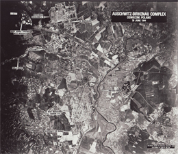
Topography of the Auschwitz Concentration Camp
(download under: Materials “Aerial photo, Auschwitz camp complex”)
© National Archives, Washington, DC
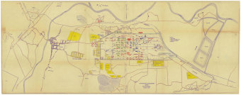
(download under: Materials “Site Plan for Auschwitz-Monowitz”)
© Fritz Bauer Institute (I.G. Farben i.L. Archive)
The Auschwitz I concentration camp, the so-called Stammlager, was the main camp of an entire complex of concentration camps in and around the town of Auschwitz. Besides the Birkenau extermination camp (initial prisoner occupancy in March 1942) and the Buna/Monowitz concentration camp (initial prisoner occupancy in late October 1942), numerous subcamps were set up.
A good overview of the three largest camps is provided by an aerial photograph taken by Allied airmen in June 1944: top left (west of the town of Auschwitz) is the Birkenau camp, slightly to the south (at left on the map) of the center of town is the main camp, and the large construction site of I.G. Farben can be seen east of the town, about 7 km from its center. Next to it is marked the Buna/Monowitz concentration camp (called “Auschwitz-Buna,” to the south, or at left on the map). The analysis of the aerial photograph and the labeling date from 1979.
(SP; transl. KL)